Pre Submission Plan
Wingrave & Rowsham Neighbourhood PlanWingrave with Rowsham
Neighbourhood Plan 2015 - 2033
PRE SUBMISSION PLAN
Published by Wingrave with Rowsham Parish Council for consultation under the Neighbourhood Planning (General) Regulations 2012 and the Environmental Assessment of Plans & Programmes Regulations 2004.
MARCH 2015
Consultation
If you have any comments to make on this Plan, please do so by 16th May 2015 at the latest in the following ways:
info@wingravewithrowshamparishcouncil.org.uk or in writing to Rebecca Biley, Parish Clerk, 24a Winslow Road, Wingrave HP22 4PS
The Wingrave & Rowsham Neighbourhood Plan website contains all the necessary background information on the Plan.
The Parish of Wingrave with Rowsham is a broad-based lively community with good resources centred in Wingrave. The aim of the Wingrave with Rowsham Neighbourhood Plan is to make the Parish an even better place for future generations and to ensure its sustainability. The Plan will have an 18 year life with a review every 5 years. It will give the community control over development sites; enable it to influence the type and quality of new building and to manage change. Without a Neighbourhood Plan we would have little power over development. With a Plan we have the opportunity to put the longer term interests of the Parish first. Rural Parishes such as ours depend for their sustainability on striking a balance between continuity and change in ways the community supports. The Parish referendum will provide the necessary validation and the incorporation of the Plan into the Aylesbury Vale Local Plan will secure it. Until the Local Plan is in place (2017) the Neighbourhood Plan will also provide a defence against unplanned and unwanted development.
David Neave - Chairman Wingrave with Rowsham Parish Council
Les Kennedy - Chairman Wingrave with Rowsham Neighbourhood Plan Group
1 - Introduction & Purpose
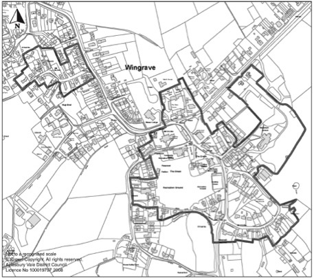
1.1 The Wingrave with Rowsham Parish Council (WRPC) is preparing a Neighbourhood Plan for the area designated by the local planning authority, Aylesbury Vale District Council (AVDC), under the provisions of the Localism Act 2011 and of the Neighbourhood Planning (General) Regulations 2012. The designated area is shown in Plan A below.
Plan A: Wingrave & Rowsham Designated Neighbourhood Plan Area
1.2 The purpose of the Wingrave & Rowsham Neighbourhood Plan (WRNP) will be to make planning policies that can be used to determine planning applications in the area. In some cases, its policies will encourage development proposals for the benefit of the local community. In others, its policies will aim to protect the special character of the parish.
1.3 Neighbourhood Plans provide local communities with the chance to shape the future development of their areas. Once approved at a referendum, the Plan becomes a statutory part of the development plan for the area and will carry significant weight in how planning applications are decided. Plans must therefore contain only land use planning policies that can be used for this purpose. This often means that there are important issues of interest to the local community that cannot be addressed in a Plan if they are not directly related to planning.
1.4 Although there is considerable scope for the local community to decide on its planning policies, Plans must meet four ‘basic conditions’. These are:
- Is the Plan consistent with national planning policy?
- Is the Plan consistent with local planning policy?
- Does the Plan promote the principles of sustainable development?
- Has the process of making of the Plan met the requirements of European environmental standards?
1.5 In addition, the WRPC must be able to show that it has properly consulted local people and other relevant organisations during the process of making the Plan and has followed the Regulations.
1.6 These requirements will be tested by an independent examiner once the Plan is finalised. If satisfied, the examiner will recommend to the AVDC that the Plan goes to a referendum of the local electorate. If a simple majority of the turnout votes for the Plan then it must become adopted as formal planning policy for the area.
The Pre Submission Plan
1.7 This Pre Submission Plan is the next opportunity for the WRPC to consult on the emerging policies and proposals of the Plan. It has reviewed existing national and local planning policies and how they may affect this area. And it has already sought the local community’s opinions on local planning issues that the Plan might help address.
1.8 The contents of this Plan are therefore presented to obtain the views of the local community and other organisations on the vision, objectives and policies of the Plan. It is deliberately brief and focused on the draft vision, objectives and policies. The final version of the Plan will take into account the representations received on this version.
History and Development of Wingrave with Rowsham Parish
1.9 Wingrave with Rowsham contains two historic communities to the north of Aylesbury on the edge of the Quainton-Wing Area of Attractive Landscape with panoramic views towards the Chiltern escarpment. Both communities were originally dominated by agriculture and have grown substantially since the Second World War.
1.10 Wingrave is a village of ancient origins located five miles to the north east of Aylesbury and lying to the south of the A418. Wingrave certainly existed at the time of the Norman Conquest and the village church dates from the 12th century. The Hamlet of Rowsham also has ancient roots, being listed in the manorial rolls of 1170. It is located slightly closer to Aylesbury than Wingrave on the A418. Originally, Rowsham was a cluster of farmsteads located above the flood plain with a small residential development located on the east side of the A418.
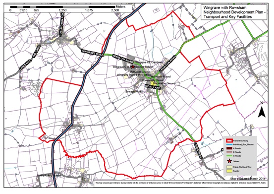
Plan B: Wingrave & Rowsham – Transport & Key Facilities
1.11 The Parish has a vibrant community with good amenities in Wingrave, which has a small local shop with a post office, a combined school, community centre, two churches, sports fields, a public house, a garage and some small business parks.
1.12 For much of its history Wingrave with Rowsham had a population of between 600 and 900 people. In recent decades this has expanded substantially and now totals 1,513 residents in the two communities. The population has grown some 45% since 1981. Though in the period since 2001 although the number of homes has increased the population has decreased. Comparing the 2001 and 2011 census shows that the there are fewer young families with children and this is reflected in the school which is slightly under roll, and currently recruits some 30% of its intake from outside the Parish.
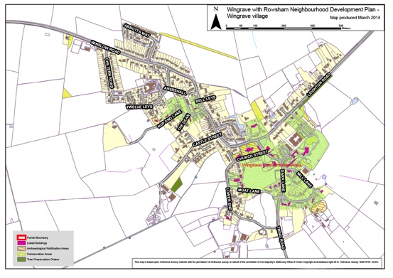
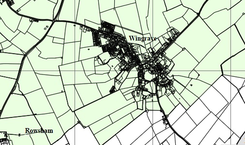
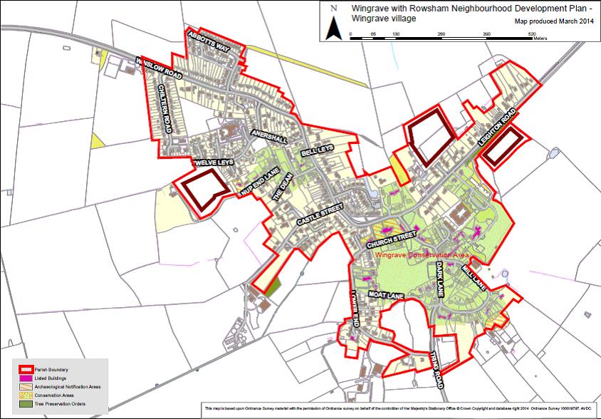
Plan C: Wingrave Village
1.13 Over the period from 1981 the Parish housing stock has expanded from 419 to 658 dwellings with the majority of development in Wingrave along Winslow Road and on some infill sites with a number of Barn Conversions.
The most recent available information from AVDC Planning Authority (November 2011) shows that there are 612 houses in Wingrave and 46 in Rowsham, as stated a total of 658 for the Parish. Housing stock in the Parish has more than doubled since 1971 when there were 320 dwellings. Since 1971 there have been developments in Wingrave around Winslow Road and throughout both communities with infill sites and Barn conversions. There have been 138 dwellings built since 1991 and 75 of these have been added since September 2002 (Source AVDC Planning).
1.14 Business development in the Parish has been based on three small business parks at Upper Wingbury Courtyard to the north of Wingrave, Lower Windmill Farm to the south of Wingrave and at Manor Farm Courtyard in Rowsham which all together house 33 operations and employ over 125 people. There are also small traders such as plumbers, electricians, builders and gardeners based in the Parish, as well as many professionals, e.g. Accountants and Lawyers plus, homeworkers. The shop, pub and garage businesses in Wingrave serve the local community and increasing passing trade. Both communities are surrounded by land used for arable farming and grazing for sheep and cows.
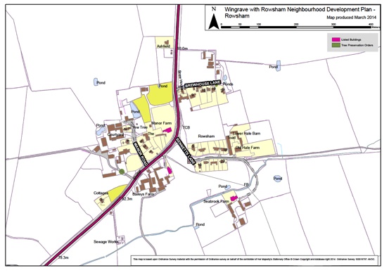
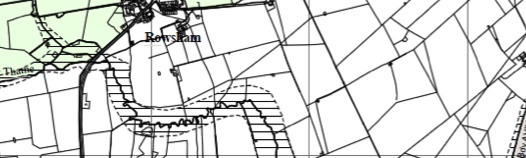
Plan D: Rowsham Village
1.15 Traffic congestion has increased in Wingrave due to more on street parking as Victorian and pre-Victorian properties generally do not to have off Street parking, plus the use of the roads through the village for access from the A418 towards the A41 at Tring and the A505 south of Leighton Buzzard. There has also been a substantial increase in traffic flow along the A 418 between Aylesbury and Wing, which runs through Rowsham.
1.16 The architectural style of a significant number of houses in Wingrave is heavily influenced by the houses constructed in the village by the Rothschild family in Tudor Revival style in the 19th Century, and is typical of the Rothschild villages near Aylesbury. The houses have characteristic features of black and white gables and red brickwork with clay-tiled roofs. But Wingrave and Rowsham have developed over a long time and the buildings reflect this in that they are eclectic and largely harmonious.
Post 1945 Development and Recent Development
1.17 In Wingrave this has included Chiltern Road, Abbotts Way and the Twelve Leys development, and Local Authority housing along Winslow Road, all at the northern end of Wingrave.
1.18 Several smaller developments have been built within Wingrave, the largest at Parsonage Farm (19 dwellings), Ravens Walk (16 dwellings) and ten others. In addition there have been a number of significant multi-dwelling barn conversion developments at Straws Hadley Court, Essex Yard, Manor Farm and Floyd`s Farm. Currently there are four properties under construction in Wingrave, a Farm dwelling at the bottom of Castle Street and three detached homes on land off Castle Street. A Planning Application has been submitted for a detached dwelling on the south side of Leighton Road and another has been approved for a dwelling off Nup End. A third of the housing stock in Rowsham has been built since 1945.
1.19 Developments during the last ten years have consisted of infill residential development including the above mentioned 16 home Raven’s Walk development and, an affordable housing group of 12 homes at the end of Chiltern Road and 9 homes at Greenacres, Church Street. In addition Mount Tabor House and Stables (formerly the MacIntyre School building) have been converted into 18 residential apartments.
Environmental Constraints
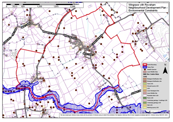
1.20 The SEA Scoping Report identifies a series of natural and heritage-related environmental constraints on planning for development in and around the villages of Wingrave and Rowsham.
1.21 Firstly, there is the Wingrave Conservation Area, which was designated in 1980 (see Plan E below). The larger area of the two covers the part of the settlement to the south east of the village and the smaller covers the area to the north west, adjacent to Winslow Road. In addition, the Parish contains 39 listed buildings, some with origins in the 14th Century and six buildings on the Statutory list of buildings of Architectural and Historic Interest.
Plan E: Wingrave Conservation Area
1.22 There are a number of natural environmental constraints, as shown on Plans F and G below, comprising primarily sites of recorded notable species and tree preservation orders. Although there are areas of flood risk they are well beyond the village boundaries. There is a small area near Abbotts Way identified by the Environmental Agency with a potential for surface flooding.
 Plan F: Wingrave Environmental Constraints
 Plan G: Rowsham Environmental Constraints

Plan H: Wingrave and Rowsham Landscape Character & Sensitivity
The Planning Policy Context
1.23 The parish lies within Aylesbury Vale District in the County of Buckinghamshire. AVDC has planning policies and proposals that are helping to shape the strategy and policies of the WRNP.
1.24 The National Planning Policy Framework (NPPF) published by the Government in 2012 is also an important guide in the preparation of local plans and neighbourhood plans. The WRNP must demonstrate that it is consistent with the provisions of the NPPF.
1.25 The WRNP must be in general conformity with the strategic policies of the development plan as required by the 2012 Neighbourhood Plan Regulations. The development plan currently comprises the saved policies of the 2004 Aylesbury Vale District Local Plan. However this plan is out of date in some respects and in anticipating the adoption of the emerging Vale of Aylesbury Local Plan (VALP) the WRNP on the reasoning and the evidence base of the withdrawn Vale of Aylesbury Plan (VAP) of 2014.
The Aylesbury Vale District Local Plan (2004)
1.26 The Aylesbury Vale Local Plan (AVLP) was adopted in January 2004. Some of the AVLP policies ceased to have effect in 2007 when planning legislation changed. The remaining policies of the AVLP were therefore called ‘saved’ and it is these policies that currently set out the spatial plan for Aylesbury Vale District Council that the WRNP must be in conformity with.
1.27 In addition to the saved policies the WRNP will look to the reasoning and evidence base of the VAP, especially the settlement hierarchy for the district. That evidence base indicated that Wingrave is a ‘larger village’ and the VAP proposed approximately 36 new homes over the plan period 2011-2031. Rowsham is identified as an unclassified settlement, with no expectation of any new housing in that period. Although the housing supply strategy of the VALP is likely to change in the light of new objectively assessed demand data, there is currently no indication of how that may affect the previous spatial strategy for distributing new homes across the hierarchy. It is safe to assume that the hierarchy of larger and smaller villages will remain much the same but that they will be expected to make a higher collective contribution to meeting the district’s housing needs than proposed in the VAP.
1.28 The 2004 AVLP saved policies set the policy framework for WRNP; these are the General Policies (GP) and the Rural Areas (RA) policies of which the most relevant are the following:
- 8 Protection of the Amenity of Residents: Protects existing residential amenities from unreasonable harm the impact from a new development may cause.
- 17 Existing employment sites: Retains Proposals for changes of use or redevelopment of employment sites.
- 32 Shopping: Resists proposals for the change of use of shops, post offices and public houses where local need can be demonstrated.
- 35 Design of new development: Sets out the built design principles for new development
- 38 Landscape Design: Sets out the landscape design principles for new development
- 53 Conservation Areas: Protects the character and appearance of Conservation Areas
- 2 Coalescence of Settlements: Retains the individuality of settlement and prevent coalescence through avoiding development on open land in the countryside that has a negative impact on the rural character and setting of settlements.
- 8 Other Important Landscapes: Identifies Areas of Attractive Landscape (AALs), which demand a high level of protection. (The green areas on the 2004 proposals Maps in Plan B show the AALs around the settlements of Wingrave and Rowsham.)
Plan J: 2004 Proposals Maps for Wingrave and Rowsham
- 13 Housing within the Built-Up Area of Settlements: Identifies settlements that may be appropriate for small scale development within the built-up area to be in keeping with the surrounding area.
- 29 Employment in the Countryside: Resists in principle new employment sites outside the built-up area of the settlement or outside identified employment areas.
- 36 Transport: Considers the impact that development in the countryside will have on the rural roads network and the character of the countryside.
1.29 These policies provide part of the framework, within which the general conformity of the WRNP with the development plan will be assessed. The WRNP should not however repeat what the district plan is saying but add local land use policies.
The Vale of Aylesbury Local Plan (2014)
1.30 The emerging Vale of Aylesbury Local Plan (VALP) will include the overall strategy for the district, alongside site allocations and development management policies. Adopted Neighbourhood Plans work as site allocation plans for their specific plan area and hold the same weight as the Local Plan.
2 - Community Views on Planning Issues
2.1 The Parish Council has striven for a constructive engagement with the Parish over the development of the Parish over the next eighteen years. Relevant activities commenced in 2011 with the production of a Community Plan which was completed in 2012.
2.2 The Community Plan process was commenced by the Parish Council in response to advice from Aylesbury Vale District Council (AVDC). AVDC advised that they were preparing a plan for the whole AVDC area and that their plan would embrace the wishes of the Parish as expressed in a Neighbourhood Plan.
2.3 A summary of that process is included below, taken as an extract from the document:
The Process (Section 1.2)
This Community Plan has been completed in response to the Government Localism Initiative and to update the previous Parish Plan, which was completed in 2004. The Plan sets out the vision that the Parish community has for its future over the next 20 years including whether the community believes the Parish can and should accommodate further development. The plan also sets the tone for the Neighbourhood Plan that is currently being considered by the Parish Council and which would provide the context for any development that would be considered by AVDC within the Parish.
The Community Plan has been prepared by the Localism Group on behalf of Wingrave with Rowsham Parish Council. The Localism Group constitutes 10 Parish residents and has been assisted by a much wider group of supporters in the various tasks of gathering opinion and evidence.
The Plan has been based on a detailed and thorough process of consultation across the Parish. This started with two open day sessions in July 2011 where residents were asked what issues were most important to them. These responses were used as the basis of a detailed questionnaire, which covered the principal issues for the context of future development in the Parish of housing, business, amenities, utilities, transport and pedestrians, and the environment.
The questionnaire was delivered to each household and business in the Parish by volunteer helpers and every adult over 16 was encouraged to respond. The response was excellent with 602 questionnaires returned from 658 households. The findings of the questionnaire were presented and discussed at an open evening held in the MacIntyre School in November 2011 which was attended by approximately100 people
The analysis and interpretation of the questionnaire responses have been the basis of this Community Plan, together with the ‘Fact Pack’ provided by AVDC in May 2011, which provides some essential data including census information.
The evidence from the questionnaire has also been used to inform Wingrave with Rowsham Parish Council, AVDC and Buckinghamshire County Council of residents’ opinions on crucial issues such as transport, pedestrian access and the provision and maintenance of amenities in the Parish.
Recommendations (Section 1.3)
The overall recommendation of this Plan is that some limited growth can and should be accommodated in the Parish, but that there is a desire to retain the village feel of each settlement.
Wingrave is generally unsympathetic to more housing as a considerable amount has been built in recent years and much of the available infill space has been utilised. Allowing a very modest one-sixth of an acre per house, the 138 houses built in the Parish in the last twenty years have probably accounted for the loss of 23 acres of open space. Combined with a generally negative view on building outside the existing building line, few options remain attractive. An initial assessment is that up to 15 dwellings would be appropriate during the 20 year plan period.
Rowsham on the other hand indicates that it has space for up to twenty houses during the 20 year plan period and that half of these could be affordable homes.
The specific desire for affordable housing needs further analysis by the Parish Council in conjunction with appropriate developers to provide a detailed assessment of demand and supply requirements.
Adding more houses would exacerbate the traffic and pedestrian problems in the villages with school children being a particular concern. Before more housing can be contemplated, a detailed plan would be required of road improvements necessary to accommodate pedestrians, perhaps involving new access roads and paths, although the visual impact of these schemes must also be taken into account, in particular in the Conservation Areas. In Rowsham, a pedestrian bridge linking the two sides of Rowsham would be desirable, although clearly this would require a more substantial residential development scheme to make this viable.
It is important that any housing should be phased gradually from 2011 to 2031 in Wingrave. As development will be based on in-fill sites this is likely to happen naturally. Some affordable housing together with a small number of commercial residential units could be developed in Rowsham over a reasonably short space of time, provided no additional access is provided to the A418. Any other development in Rowsham should be phased over the 20year plan period.
Any development in either village must be accompanied by an environmental assessment report, a traffic impact assessment, and a utilities report and must provide evidence that further strain on pedestrians, road congestion, utilities, village amenities and the environment will not occur or that suitable mitigating actions will be taken.
2.4 During the Community Plan process it became evident that the proposed AVDC Plan would not ensure appropriate, balanced, development in line with the wishes of the Parishioners. Further with the withdrawal of the Vale of Aylesbury Plan in early 2014 resulted in even more concern, as this meant that AVDC would have to substantially increase the number of homes in its District.
2.5 At briefings by AVDC and others, AVDC Parishes were advised that upwards of 30,000 new homes would be required in the plan period. Parishes were privately advised to prepare Plans with substantially more homes than previously envisaged. Wingrave was advised to consider in excess of 80 new homes. AVDC reported that the new plan for the District would not be approved until 2017 leaving a substantial period for opportunistic planning applications by developers.
2.6 As can be seen from the Community Plan consultations this was a much greater number than Wingrave thought appropriate. In response to this the Parish Council Neighbourhood Development Plan Steering Group set about a new consultation process. Data was gathered on Village demographics, 2011 Census data and other Village information including the School Roll.
2.7 This data showed clearly that the Village had an aging population with fewer young families, although the number of homes had increased since the 2001 Census the actual Village population had decreased. House prices have increased such that young families cannot afford to buy homes in the village; also as the population ages there are few properties for villagers to downsize to when their current homes are no longer manageable. The school is under Roll with some 30% of pupils bussed in from outside Wingrave. Wingrave has clear sustainability issues.
2.8 A process of new consultation was begun, this included Consultation events which were posted on the Village wide e-mail Postie system, information in the Parish magazine, and banners in prominent places in the Parish. Facsimiles of two such banners are shown below.

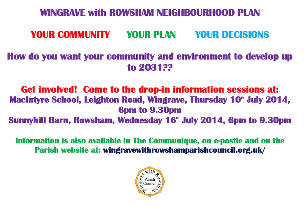
2.9 In addition to the events listed on the banners shown above there were events at the Wingrave Community Centre, Rowsham and at Wingrave Village Fete; - there were five engagement events in total. All these events had information stands showing amongst other things Parish maps, showing land around the Parish that may or not be developable, questionnaires on Housing preferences, Parish amenities, roads and Infrastructure and resources such as the Village shop and Post Office, schools, employment etc. In total approximately 15% of eligible people in the Parish participated which was a disappointment in comparison to the previous Community Plan engagement. On investigation it was revealed that a lot of Parishioners believed that their responses to the previous Community Plan were enough and they did not need to respond again.
2.10 Analysis of the data collected at these five events showed a wide age range of participants and the participants were distributed around the Parish and thus were overall representative. Housing as to be expected is a key issue. Analysis showed that we had as a Parish a view that more affordable and more rented property was need in the Parish. Whilst presented with the data on Parish demographics the data shows a failure to understand the implications on sustainability.
 Figure 1: Opinions on Housing Strategy
2.11 Asked about the types of houses the major issue to respondents was that houses should be in character with the Parish, followed by house sizes should be a mixture with a preference for one to three bedroom homes rather than larger homes and that housing cost was an issue as was the need for homes for the elderly who wished to stay in the parish in their older years.
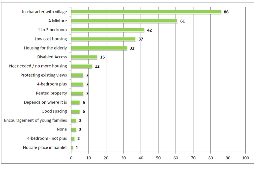 Figure 2: Opinions Types of Housing
2.12 Car parking and traffic are major concerns in both Wingrave village and Rowsham. The Rowsham problem is the A418. This divides the community north and south nearly as effectively as a river with measured traffic flows in 2010 of between 12,000 and 20,000 vehicles per day, that is worst case over 800 vehicles per hour throughout the day. In Wingrave there are many Victorian and pre-Victorian homes with no off road parking and even modern homes often do not have sufficient off road parking. As previously stated the village suffers from considerable through traffic for access from the A418 towards the A41 at Tring and the A505 south of Leighton Buzzard. Thus in consultations the impact of additional traffic is of significant concern. Parishioners input to traffic transport and related Pedestrian concerns are detailed in the graphs following.
2.13 Overall the responses to the consultations on issues relating to the Parish were the same as the previous consultations for the 2012 Community Plan which had a far large sample of residents. The gathered data was used to inform the site selection sub-group of the Neighbourhood Plan Steering Group as to the key criteria from a parish perspective in site selection for development.
2.14 In the period since summer 2014 update reports on the Neighbourhood Plan have been presented to the Parish Council and reports have been published in the Parish Magazine. Two Parish Council meetings have been held relating to the Neighbourhood Plan one held with potential Developers presenting outline plans; this meeting was well attended by Parishioners.
2.15 Regular reports from the Neighbourhood Planning group have been made to the Parish Council where parishioners were given the opportunity to question and comment.
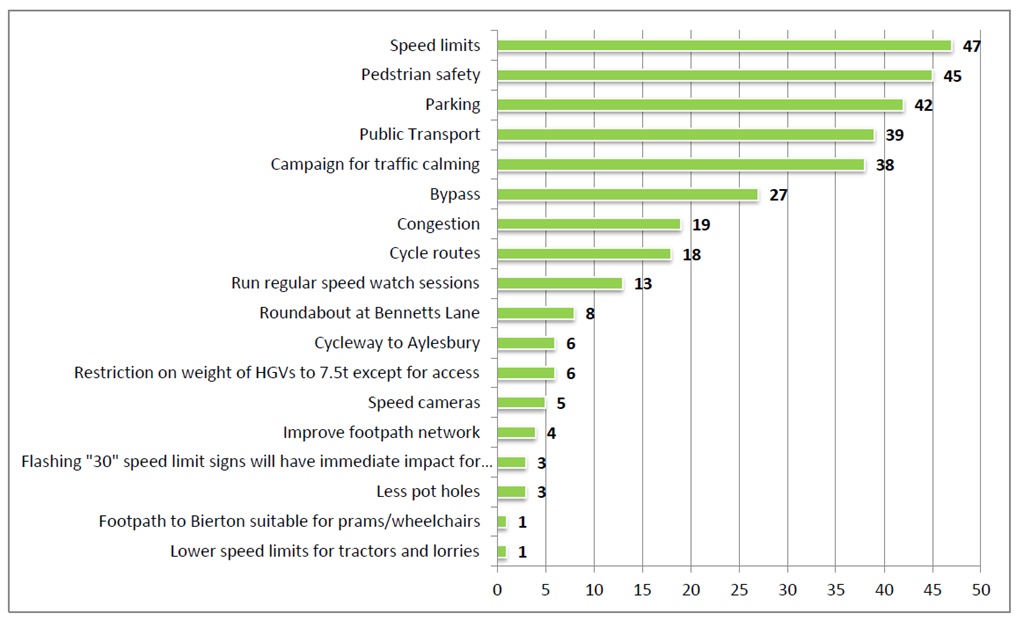 Figure 3: Opinions on Traffic, Transport and Pedestrians
2.16 Consultation events were held on 20th and 21st February 20th to determine the Parish’s choice of optimum development sites. To ensure maximum attendance all properties were professionally leafleted by a leafleting company that uses staff with satellite trackers so that they can demonstrate that they have been to each household, additionally banners advertising the events were placed in three strategic places in the Parish and the Parish e-mail Postie service were all used to advertise the events. The events were attended by 25% of the Parish from various parts of the community and were simultaneously harmonious and contentious. With the Neighbourhood Plan Steering Group being both congratulated on tackling a challenging and difficult task responsibly and being challenged on vested interests and inappropriate decision making on sites.
2.17 All the Neighbourhood Plan Steering Group can demonstrate that they have no vested interest in the sites put forward for development or conversely no vested Interest in ensuring that the sites not being put forward were not developed.
3 - Vision & Objectives
Vision
3.1 The vision for Wingrave & Rowsham in 2031 is:
“The settlements of Wingrave and Rowsham will have preserved their own distinctive characters with the quality of the landscape spaces between them continuing to define their identity.
The Wingrave Conservation Areas and Listed Buildings that help define the village and its special historic and architectural character will have been protected.
Housing growth at Wingrave will have been contained by a clearly defined settlement boundary that will have preserved the quality of the setting to the village.
The gradual provision of new homes over the plan period will have met the local need for housing, notably of older households wanting to downsize and of new households, especially those from the local area, wanting to buy their first home and young families.
There will have been a growth in employment opportunities at the local businesses in the area. The local community facilities will have improved and become more varied to meet the needs of all groups and age ranges of the increased population.”
Objectives
3.2 In addition to providing a general development plan for the parishes, this vision translates into a framework of key objectives for the WRNP that:
Environment
- to define the settlement boundary of Wingrave as a ‘larger village’ to reflect the current extent of the village and to enable new development at suitable locations on its edge
- to provide for appropriate growth within the village but to retain the rural character of the parish through recognising the separate identities of Wingrave and Rowsham by protecting the landscape and to prevent coalescence
- to protect important green spaces from development
- to establish a Green Infrastructure Network through linking green spaces and footpaths in the area and by connecting habitat corridors
New Homes
- to meet the housing needs of the local community and to contribute to meeting the needs of the wider district
Community Facilities
- to protect community facilities from loss and to encourage their ongoing viability as valuable community assets
Local Economy
- to support local economic development by protecting existing employment sites and encouraging their growth
4 - Land Use Planning Policies
Policy Issues
4.1 The Planning policy context and the community engagement work already undertaken have a number of issues for the Neighbourhood Plan to address:
- Where should new housing in Wingrave be located? Is the land available now or might it become available later in the plan period?
- What are the shared design characteristics of the settlements that could be included in a policy? How could the character principles of the Conservation Area be incorporated?
- Should the employment policy promote new business development at Wingbury Courtyard? Should Wingrave Garage site be protected as an employment/commercial use?
- What community facilities would be on the list of those to be protected from a change of use?
- Which spaces meet the criteria for designation as Local Green Spaces?
- Where are the existing public rights of way and areas of habitat value? Can these be improved to better serve the settlements as footpaths and cycleways? Will new development enable improvements to fragmented or damaged habitats?
4.2 The purpose of the Plan is to test the opinions of the community and others on how the Parish Councils are proposing to address these issues before they commit to publishing the final version of the Plan. These proposals for planning policies are set out in the next section.
Land Use Policies
4.3 Land use policies are used to determine planning applications made for development proposals. They can establish the principles for retaining or changing the use of land in settlements and in the countryside. They can also set out the conditions against which development proposals will be judged in terms of their design, access etc.
4.4 The purpose of these policies is to either encourage planning applications to be made for things the local community wants to see happen or to discourage applications for developments that they do not want to happen. Policies must be clearly written so they can be easily applied when considering planning applications.
4.5 The Plan deliberately avoids repeating existing national or local planning policies. The proposed policies therefore focus on a relatively small number of key development issues in the area. For all other planning matters, the national and local policies of other planning documents – the National Planning Policy Framework and the saved policies of the Aylesbury Vale District Local Plan 2004 – will continue to be used.
4.6 Set out below are the proposed policies of the Plan. Each policy has a number and title and the policy itself is written in bold italics for ease of reference. There is also a short statement explaining the intention of the policy and any other relevant background information. At the end of this document is the Policies Map – where a policy refers to a specific site or area then it is shown on the Map.
Policy 1: A Spatial Plan for the Parish
The Neighbourhood Plan designates a Wingrave Settlement Boundary, as shown on the Policies Map, for the purpose of containing the physical growth of the settlement over the plan period.
Development proposals on land outside the defined settlement boundaries will not be permitted in the countryside unless it is necessary for the purposes of agriculture or forestry, or for enterprise, diversification or recreation that benefits the rural economy without harming countryside interests. New development in the countryside should not result in the loss of open land that contributes to the form and character of Wingrave and Rowsham.
4.7 This policy establishes and defines the Wingrave Settlement Boundary (WSB) to distinguish the consideration of planning applications within the settlement from those outside the boundary. In doing so, it replaces saved AVLP policies RA3 and RA13 relating to development within and adjoining rural settlements in so far as they are applied in the designated neighbourhood area.
4.8 The WSB is principally derived from the definition of the ‘built up area’ in the AVLP:
“land within the settlement framework principally occupied by permanent buildings. This would not normally include recreation or amenity land, playing fields, allotments or similar open or wooded areas that contribute to the settlement form, or large grounds and gardens on the rural margins of settlements”. (para 10.48)
4.9 Its purpose is to clearly translate this definition to the Proposals Map in respect of Wingrave village, which was defined as an ‘Appendix 4’ settlement in relation to the application of saved policy RA13 of the AVLP. It has been defined to include land that is proposed for allocation for housing development in Policies 2, 3 and 4 of the WRNP. In this way, the WRNP can make a positive contribution towards the supply of new homes to meet local demand and need. Over the full plan period, these allocations will deliver in the region of 100 new dwellings, in addition to any ‘windfall’ schemes that are consented. This will represent an increase of approximately 16% in the number of households in the village.
4.10 Aside from addressing the need for open market and affordable housing, this level of housing supply is consistent with the proposed status of Wingrave as a ‘large village’ (as defined in the 2012 AVDC Settlement Hierarchy Assessment). The withdrawn Vale of Aylesbury Plan (VAP) of early 2014 proposed villages of this status should plan for approximately 50 new homes over the plan period. With the likelihood that the new Vale of Aylesbury Local Plan will propose higher levels of housing growth in due course, the total housing supply derived from the allocations of this policy is more likely to be consistent with that plan. However, should its provisions be insufficient to the extent that this policy becomes out-of-date, then an early review of the WRNP may be undertaken to identify additional housing sites within or adjoining the WSB.
4.11 The total housing provisions of the WRNP therefore seek to support sustainable development by striking an appropriate balance between meeting housing need and accepting the lack of social, employment and commercial supporting infrastructure to sustain a significantly larger village population and its important heritage and landscape assets. They also directly address the desire of the local community to see the village grow in incremental steps.
4.12 The selection of housing allocation sites in Policy 2 was firstly determined by the community’s expressed preference for a spatial strategy that disperses new development around the edges of the village but avoiding the most sensitive locations. The consultation events expressed a preference for the combination of sites now proposed, with one of the four sites consulted on not being included in the WRNP.
4.13 In addition, the spatial option of allocating only one, much larger site at Bell Corner, on the northern edge of the village was not considered a reasonable alternative. This site, capable of delivering many more than 100 homes across its full extent, was clearly contrary to the expressed community preference for the WRNP to allocate a number of smaller sites rather than one larger site.
4.14 The policy provides for development proposals outside the WSB in the remainder of the parish in line with saved policy RA2 of the Local Plan that states “new development in the countryside should avoid reducing open land that contributes to the form and character of rural settlements”. It also assumes saved policy RA8, which designates much of the parish as part of a larger Area of Attractive Landscape, will continue to apply. The area of open countryside outside the WSB makes an important contribution to the landscape setting and rural character of the village, especially in respect of the long public views to it in approaches from the east and south.
4.15 No such boundary is proposed for Rowsham. However, the Parish Council is aware of the desire of many Rowsham residents to secure both new housing development and a green space for recreation in the hamlet. In reviewing the Neighbourhood Plan, the Council will consider proposals to achieve those objectives provided they are supported by the Rowsham community.
4.16 The Draft SEA assessment has indicated that the policy has significant positive environmental effects.
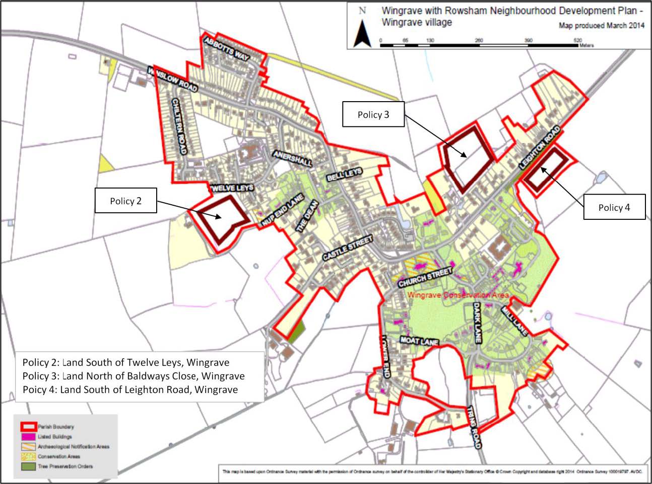
Policy 2: Land South of Twelve Leys, Wingrave
The Neighbourhood Plan allocates 1.62 Ha of land south of Twelve Leys and north of Nup End Lane, Wingrave, as shown on the Policies Map, for housing development of approximately 30 dwellings.
Development proposals will be supported, provided they accord with the following principles:
- 35% of the total homes provided on site shall be affordable homes, unless it can be demonstrated that a smaller percentage is required to deliver a viable scheme;
- The built form shall include a frontage to Twelve Leys, which may include access to driveways;
- The built form shall include a frontage to Nup End Lane but shall not include any access to driveways;
- The vehicular access to the remainder of the site shall be off Twelve Leys only;
- Parking shall be integrated with the open space and buildings to create a safe and attractive pedestrian environment and to avoid parking problems on local roads;
- A private car park shall be provided, either on the site or adjoining the site and fronting Twelve Leys, for the benefit of residents of Twelve Leys;
- The site layout shall consider views, and protect privacy and amenity of existing dwellings and back gardens; and
- The layout and landscape shall provide public open space within the site that:
- Sustains and enhances the significance of the adjoining heritage asset and its setting by providing a buffer between buildings and the asset;
- Preserves the public right of way across the site on its existing alignment;
- Retain and improve the existing hedgerows and trees on the site boundaries; and
- Creates an attractive setting and amenity for the development.
4.17 This policy allocates land for housing development on the western edge of Wingrave village. In doing so, it proposes a series of development principles that will act to mitigate the environmental effects of development of a green field scheme on land adjoining a heritage asset, with a public right of way crossing the site and with open views to the countryside beyond.
4.18 The Draft SEA assessment has indicated that the policy contains sufficient mitigation measures to avoid any significant environmental effects.
Policy 3: Land North of Baldways Close, Wingrave
The Neighbourhood Plan allocates 1.8 Ha of land north of Baldways Close, Wingrave, as shown on the Policies Map, for housing development of approximately 40 dwellings.
Development proposals will be supported, provided they accord with the following principles:
- 35% of the total homes provided on site shall be affordable homes, unless it can be demonstrated that a smaller percentage is required to deliver a viable scheme;
- The vehicular access shall be off Baldways Close;
- Parking shall be integrated with the open space and buildings to create a safe and attractive pedestrian environment and to avoid parking problems on local roads; and
- The site layout shall consider views, and protect privacy and amenity of existing dwellings and back gardens;
- The landscape scheme shall create a strong, attractive and defensible long term settlement edge on its northern, western and eastern boundaries to the open countryside beyond; and
- The layout and landscape shall provide public open space within the site that:
- Preserves the public right of way across the site on its existing alignment; and
- Creates an attractive green space and amenity for the development
4.19 This policy allocates land for housing development on the north-eastern edge of Wingrave village. In doing so, it proposes a series of development principles that will act to mitigate the environmental effects of development of a green field scheme on land with a public right of way crossing the site and with open views to the countryside beyond.
4.20 The Draft SEA assessment has indicated that the policy contains sufficient mitigation measures to avoid any significant environmental effects.
Policy 4: Land South of Leighton Road, Wingrave
The Neighbourhood Plan allocates 1.4 Ha of land south of Leighton Road, Wingrave, as shown on the Policies Map, for housing development of approximately 30 dwellings.
Development proposals will be supported, provided they accord with the following principles:
- 35% of the total homes provided on site shall be affordable homes, unless it can be demonstrated that a smaller percentage is required to deliver a viable scheme;
- The vehicular access shall be off Leighton Road in a manner that minimises the loss of the protected trees on the road frontage;
- A private car park shall be provided, either on the site or adjoining the site and fronting Leighton Road, for the benefit of residents of Leighton Road;
- The scheme layout shall provide for buildings facing towards, but with no vehicular access, to Leighton Road to provide a positive street edge;
- Parking for houses in the scheme shall be integrated with the open space and buildings to create a safe and attractive pedestrian environment and to avoid parking problems on local roads; and
- The landscape scheme shall create a strong, attractive and defensible long term settlement edge on its three boundaries to the open countryside beyond; and
- The layout and landscape scheme shall:
- allow for glimpse views through the site from existing properties on Leighton Road to the open countryside to the south and east of the site;
- Create an attractive setting and amenity for the development;
- Have regard to sustaining and enhancing the significance of proximate heritage assets and their setting; and
- Improve the quality and management of the landscape area to the Leighton Road frontage.
4.21 This policy allocates land for housing development on the eastern edge of Wingrave village. In doing so, it proposes a series of development principles that will act to mitigate the social and environmental effects of development of a green field scheme on land close to the Conservation Area and listed structures and with open views to the countryside beyond.
4.22 It specifically requires that in creating a site access and visibility splay the loss of protected trees along Leighton Road is kept to a minimum. It also requires the provision of a community benefit in the form private car park for the use of residents of Leighton Road to address the lack of off-street spaces in that part of the village. This may be provided within the site boundary or on other land in the control of the landowner adjoining the site and fronting Leighton Road.
4.23 The Draft SEA assessment has indicated that the policy contains sufficient mitigation measures to avoid any significant environmental effects.
Policy 5: Design
The scale, density, massing, height, landscape design, layout and materials of all development proposals, including alterations to existing buildings, will be required to reflect the architectural and historic character and scale of the surrounding buildings.
In addition to the above design requirements, proposals for infill housing development should have regard to their effects on local amenity in respect of their proximity to the boundary of adjoining properties and their car parking arrangements.
4.24 This policy requires all development proposals to deliver high quality schemes that reflect the distinct character of the two settlements.
4.25 This policy complements the AVDC saved policy GP.8, GP.35, GP.38 and GP.53 as it requires all new development to respect the character, identity and context of the district’s villages and countryside and helps to create places where people want to live, work and visit.
4.26 The Draft SEA assessment has indicated that the policy will not have any significant environmental effects.
Policy 6: Local Employment
Proposals that result in the loss of an existing employment use will be resisted, unless it can be demonstrated that its continued use is no longer viable.
Proposals that will lead to additional employment will be supported in the following locations, as shown on the Policies Map:
- Wingbury Courtyard Business Village, provided their traffic impact on Leighton Road and their visual impact on the landscape can be satisfactorily mitigated and sufficient provision is made for additional on-site car parking;
- Seven Acres/Lower Windmill Farm, provided their traffic impact on Tring Road and their visual impact on the landscape can be satisfactorily mitigated and sufficient provision is made for additional on-site car parking;
- Manor Road, Rowsham, provided their traffic impact on the A418 junction with Manor Road and their visual impact on the landscape and on the amenities of adjoining residential properties can be satisfactorily mitigated and sufficient provision is made for additional on-site car parking; and
- MacIntyre School, provided their traffic impact on Leighton Road and their visual impact on the landscape can be satisfactorily mitigated and sufficient provision is made for additional on-site car parking.
Proposals that provide infrastructure to enable access to a superfast broadband network to serve both communities and properties adjoining the network in the countryside will be supported. New housing development should provide the necessary means for new residents to access the superfast broadband network when it becomes available and if possible, contribute to improvements in the service for existing residents and businesses.
4.27 This policy has a number of purposes relating to employment uses in the parish. Firstly, it resists the unnecessary loss of an existing employment use, as the current uses in the parish offer a range of job opportunities. Secondly, it encourages proposals at the four main employment sites to intensify and/or extend their employment uses, provided any environmental impacts can be satisfactorily mitigated. It is therefore consistent with the AVDC’s saved policy GP.17 in safeguarding sites for employment use and in continuing to play an important role in accommodating Buckinghamshire’s business activity.
4.28 Finally, it acknowledges the importance of access to genuine fixed and mobile superfast broadband services for these locations and for local residents to maintaining modern businesses and supporting home life. It therefore is permissive in allowing for proposals for new above-ground infrastructure to enable access to these services.
4.29 The Draft SEA assessment has indicated that the policy contains sufficient mitigation measures to avoid any significant environmental effects.
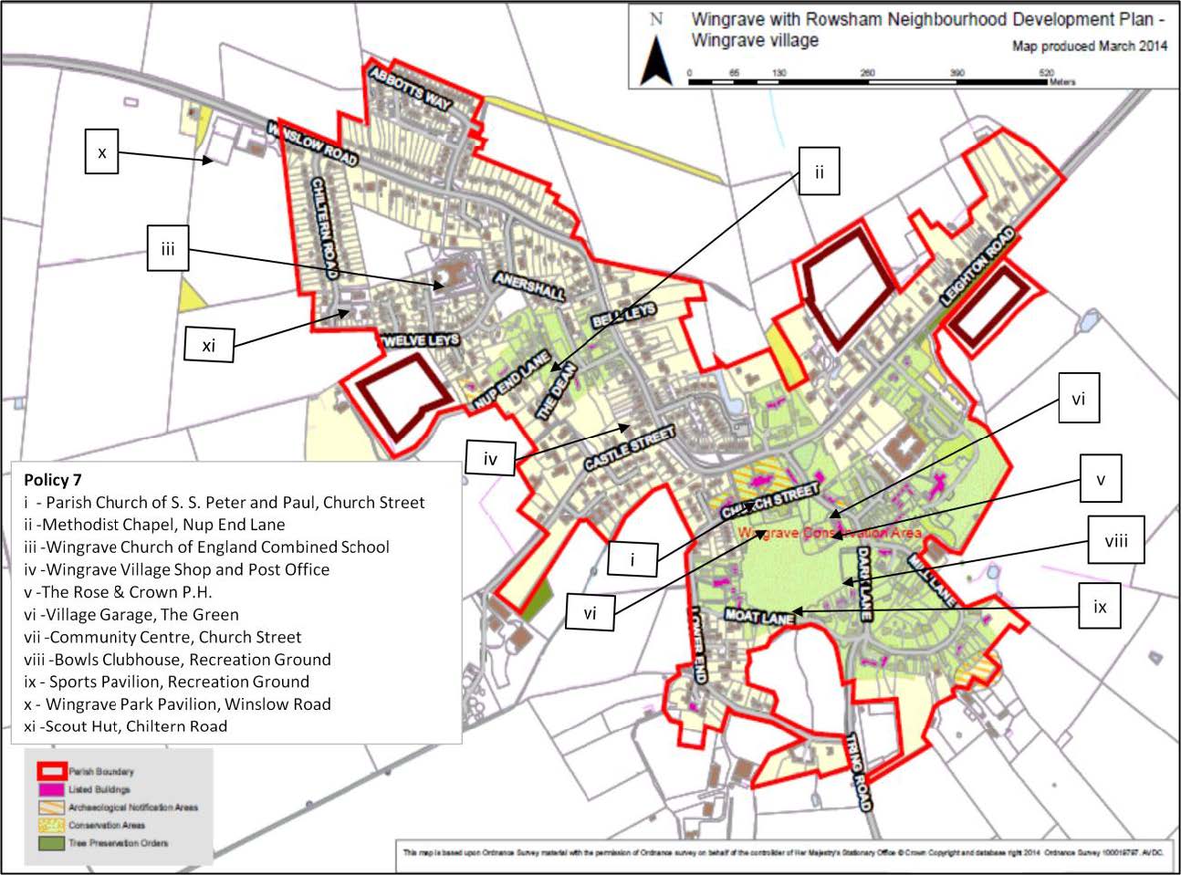
Policy 7: Wingrave Community Facilities
Proposals that will result in the loss of a valued community facility, as listed below, will be resisted unless it can be demonstrated that they are no longer viable:
- Parish Church of S. S. Peter and Paul, Church Street
- Methodist Chapel, Nup End Lane
- Wingrave Church of England Combined School
- Wingrave Village Shop and Post Office
- The Rose & Crown P.H.
- Village Garage, The Green
- Community Centre, Church Street
- Bowls Clubhouse, Recreation Ground
- Sports Pavilion, Recreation Ground
- Wingrave Park Pavilion, Winslow Road
- Scout Hut, Chiltern Road
Proposals to improve the viability of an established community use of the buildings by way of the extension or partial redevelopment will be supported, provided the design of the scheme and the resulting increase in use are appropriate in design terms and will not harm the amenities of adjoining residential properties. Where a facility is a designated heritage asset, then the proposals must demonstrate that it will cause less than substantial harm to the asset or its setting.
4.30 This policy supports development proposals intended to secure the long term benefit of a range of community facilities that are important to local people. In some cases, remaining viable will require investment in updating and/or increasing the size of the facility to support new uses. The policy is in line with saved policy GP32 of the AVLP in that it supports the retention of existing community facilities if their viability can be demonstrated.
4.31 The policy identifies those uses that the local community strongly favours are retained. They comprise a range of buildings and associated land, all of which may be capable of being extended or redeveloped in ways that are suitable to a rural location. However, the policy requires that proposals avoid increasing the use of community facilities to the extent that they may harm the amenities of adjoining residential properties, for example through traffic movements, on-street car parking and noise or light pollution.
4.32 The Draft SEA assessment has indicated that the policy contains sufficient mitigation measures to avoid any significant environmental effects.
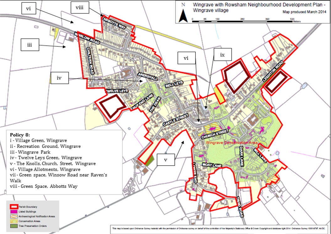
Policy 8: Local Green Spaces
The Neighbourhood Plan designates Local Green Spaces in the following locations, as shown on the Policies Map:
- Village Green, Wingrave
- Recreation Ground, Wingrave
- Wingrave Park
- Twelve Leys Green, Wingrave
- The Knolls, Church Street, Wingrave
- Village Allotments, Wingrave
- Green space on Winslow Road near Ravens Walk
- Green space on Abbotts Way
- Pond on Parsonage Farm
Proposals for development on the land that is not ancillary to the use of the land for public recreation or essential utility works purposes will be resisted.
4.33 This policy proposes a number of important green spaces in the parish to be protected from development by the designation as Local Green Spaces in accordance with the NPPF.
4.34 In each case, the green spaces are an integral part of Wingrave village and are therefore regarded as special to the local community. The WRNP Local Green Spaces study (in the evidence base) sets out the case for each site to be designated. Once designated, the policy will resist all proposals for development unless it can be clearly demonstrated they are minor, they are ancillary to a public recreation use or they are required utilities development.
4.35 The Draft SEA assessment has indicated that the policy will not have any significant environmental effects.
5 - Implementation
5.1 The Neighbourhood Plan will be implemented through a combination of the local planning authority’s consideration and determination of planning applications for development in the parish, and through steering public and private investment into a series of infrastructure proposals contained in the plan.
Development Management
5.2 Most of the policies contained in the WRNP will be delivered by landowners and developers. In preparing the plan, care has been taken to ensure, as far as possible, that the policies are achievable.
5.3 Whilst the local planning authority will be responsible for development management, the Parish Council will also use the WRNP to frame its representations on submitted planning applications. It will also work with the District Council to monitor the progress of sites coming forward for development.
Infrastructure Projects
5.4 The Parish Council proposes some or all of the following projects for investment of future Community Infrastructure Levy funding allocated by the local planning authority and to the Parish Council:
- Footpath improvements
- Car parking improvements near the primary school
- Traffic calming
- Biodiversity projects
- Provision of green space in Rowsham
5.5 This series of local infrastructure projects will be prioritised for investment from the Aylesbury Vale Community Infrastructure Levy (CIL) when it is introduced. The CIL will replace the pooling of more than four S106 agreement financial contributions towards a single infrastructure project during the plan period. It will be charged on qualifying residential and commercial development. A minimum of 25% of the levy collected from development in the Parish will be passed to the Parish Council for investment in the Parish. The list above provides the local community with an indication of the priorities for investing the fund to improve local infrastructure as a result of new development.
5.6 In addition, other policies of the WRNP require some planning obligations to be entered into as part of planning consents to finance and deliver specific infrastructure projects relating to the development scheme in order to make the scheme satisfactory in line with paras 173 and 204 of the NPPF.
List of Land Use Policies
| Policy 1: A Spatial Plan for the Parish |
| Policy 2: Land South of Twelve Leys, Wingrave |
| Policy 3: Land North of Baldways Close, Wingrave |
| Policy 4: Land South of Leighton Road, Wingrave |
| Policy 5: Design |
| Policy 6: Local Employment |
| Policy 7: Wingrave Community Facilities |
| Policy 8: Local Green Spaces |
Policies Maps
Policy 1
Policies 2, 3 & 4
Policy 7
Policy 8
Appendix A: Evidence Base Documents
The list below contains all those documents collected and reviewed in the process of preparing this report. All are available to view via the Aylesbury Vale and/or Parish Council website neighbourhood plan pages.
| Wingrave with Rowsham Community Plan (2011) |
| Wingrave with Rowsham Neighbourhood Plan Site Assessments Report (2015) |
| Wingrave with Rowsham Neighbourhood Plan Local Green Space Study (2015) |
| Wingrave with Rowsham Neighbourhood Plan Draft SEA report (2015) |
| Wingrave with Rowsham Neighbourhood Plan SEA Scoping Report (2014) |
| Aylesbury Vale Employment Land Review Update (2012) |
| Vale of Aylesbury Plan: Pre-Submission (2013) |
| Vale of Aylesbury Plan: Wingrave with Rowsham Fact Pack (2011) |
| Aylesbury Vale Strategic Flood Risk Assessment (2007) |
| Vale of Aylesbury Plan: Pre-Submission Sustainability Appraisal (2012) |
| Vale of Aylesbury Plan: Housing & Economic Growth Assessment (2011) |
| Vale of Aylesbury Plan: Infrastructure Delivery Plan (2011) |
| Vale of Aylesbury Plan: Community Infrastructure Levy Viability Appraisal (2012) |
| Aylesbury Vale Strategic Housing Land Availability Assessment (2013) |
| Aylesbury Vale Settlement Hierarchy Study (2012) |
| Aylesbury Vale District Local Plan (2004) |
| Aylesbury Vale Economic Development Strategy (2012) |
| Aylesbury Vale Landscape Character Assessment (2008) |
| Buckinghamshire & Milton Keynes Environmental Record Centre data |
