Draft Strategic Environmental Assessment Report
Wingrave & Rowsham Neighbourhood Plan
Wingrave with Rowsham
Neighbourhood Plan 2015 - 2033
Draft Strategic Environmental Assessment Report
Published by Wingrave with Rowsham Parish Council for consultation under the Neighbourhood Planning (General) Regulations 2012 and the Environmental Assessment of Plans & Programmes Regulations 2004.
MARCH 2015
Non Technical Summary
- The purpose of this report is to provide an assessment of any significant environmental effects resulting from the policies and proposals of the Pre-Submission version of the Wingrave with Rowsham Neighbourhood Development Plan in accordance with EU Directive 2001/42 on strategic environmental assessment (SEA).
- The Neighbourhood Plan contains a number of policies for the use and development of land in the Parish of Wingrave with Rowsham in the plan period up to 2033. These policies, together with the policies of the development plan - that is the Aylesbury Vale Local Plan (AVLP) - and the National Planning Policy Framework (NPPF), will be used by the District Council in determining planning applications once the Neighbourhood Plan is approved in due course. Depending on the adoption of the emerging Local Plan, the Neighbourhood Plan will either be judged by but will in any case be informed by its reasoning and evidence base.
- The Neighbourhood Plan area contains a number of designated heritage and nature features, including a number of listed buildings in and around both communities. The Wingrave Conservation Area is in two parts and covers the main part of the older village; the District Council has indicated that it will undertake an appraisal of the Conservation Area with a view to revising the boundary.
- The parish is approximately 5 miles north of the Chiltern Area of Outstanding Natural Beauty. All of Wingrave village and that part of the parish north of Rowsham lie within a designated Area of Attractive Landscape. There are also a number of tree preservation orders in the villages.
- The planning policy context and the community engagement work undertaken have raised a number of issues for the Neighbourhood Plan to address:
- Where should new housing in Wingrave be located? Is the land available now or might it become available later in the plan period?
- What are the shared design characteristics of the settlements that could be included in a policy? How could the character principles of the Conservation Area be incorporated?
- Should the employment policy promote new business development at Wingbury Courtyard? Should Wingrave Garage site be protected as an employment/commercial use?
- What community facilities would be on the list of those to be protected from a change of use?
- Which spaces meet the criteria for designation as Local Green Spaces?
- Where are the existing public rights of way and areas of habitat value? Can these be improved to better serve the settlements as footpaths and cycleways? Will new development enable improvements to fragmented or damaged habitats?
- The issues highlight no significant sustainability issues that are not also common to villages in rural England. The challenge for the Plan will be in ensuring the status of Wingrave as a viable larger village by discouraging the loss of its local services and by encouraging housing and employment growth without harming its special rural character.
- There is a strong, positive correlation between the environmental objective of the Plan and the environmental protection objective of the SEA. The Plan is explicit in wishing to plan for growth that avoids harming the rural character of the parish and especially its heritage assets.
- In all other respects, the relationship between the Neighbourhood Plan objectives and the key environmental measures is neutral. Although housing development and proposals to enhance the local economy will inevitably have some degree of environmental impact, the SEA objectives anticipate this and allow for Plan objectives that direct growth to types and locations that avoid the most sensitive environments and that successfully mitigate impacts. Given the national planning policy context, it was not a reasonable alternative to seek to avoid growth at all.
- The assessment shows that there are no significant adverse effects resulting from the policies of the Plan. The policies have been specifically chosen and formulated to adhere to the principles of sustainable development as defined by the Aylesbury Vale District Local Plan Strategy and the NPPF.
- The conclusion of the draft assessment of the objectives and policies of the Neighbourhood Plan is very encouraging. There is a close correlation between the plan’s objectives and those of the sustainability appraisal, perhaps as should be expected from a community-driven document. The policies have clearly been selected and drafted to ensure that any potential for negative impacts is avoided through site selection and effective policy wording. In a number of cases, the Neighbourhood Plan should deliver positive benefits. There are some reasonable alternative policy options but in no case does that alternative score as well against the chosen policy and there is therefore no case for policy changes as a result.
1 - Introduction
1.1 The purpose of this report is to provide an assessment of any significant environmental effects resulting from the policies and proposals of the Pre-Submission version of the Wingrave with Rowsham Neighbourhood Development Plan (“the Neighbourhood Plan”) in accordance with EU Directive 2001/42 on strategic environmental assessment (SEA). Figure A below shows the designated Neighbourhood Area.
1.2 The Neighbourhood Plan has been published for pre-submission consultation by Wingrave with Rowsham Parish Council under the Neighbourhood Planning Regulations 2012. Aylesbury Vale District Council (“the District Council”) has issued a screening opinion requiring an SEA of the Neighbourhood Plan under the Environmental Assessment of Plans & Programmes Regulations 2004.
1.3 The Draft SEA report therefore provides an assessment of the Neighbourhood Plan in a way that is proportionate to this task and that recognises the limitations of the available data and means of measuring direct impacts.
1.4 A Scoping Report was consulted upon with the statutory consultees in February/March 2015. It contains the baseline information for this report and is appended to this report.
Plan A: Wingrave & Rowsham Designated Neighbourhood Plan Area
2 - Background to Strategic Environmental Assessment
2.1 A Strategic Environmental Assessment (SEA) involves the evaluation of the environmental impacts of a plan. The requirement for an SEA is set out in the European Directive 2001/42/EC adopted into UK law as the “Environmental Assessment of Plans or Programmes Regulations 2004” as follows:
- An outline of the contents, main objectives of the plan, and relationship with other relevant plans or programmes
- The relevant aspects of the current state of the environment and the likely evolution thereof without implementation of the plan
- The environmental characteristics of areas likely to be significantly affected
- Any existing environmental problems which are relevant to the plan including, in particular, those relating to any areas of a particular environmental importance, such as areas designated pursuant to Directives 79/409/EEC and 92/43/EEC
- The environmental protection objectives, established at international, community or national level, which are relevant to the plan and the way those objectives and any environmental considerations have been taken into account during its preparation
- The likely significant effects on the environment, including on issues such as biodiversity, population, human health, fauna, flora, soil, water, air, climatic factors, material assets, cultural heritage including architectural and archaeological heritage, landscape and the interrelationship between the above factors
- The measures envisaged to prevent, reduce, and as fully as possible offset any significant adverse effects on the environment of implementing the plan
- An outline of the reasons for selecting the alternatives dealt with, and a description of how the assessment was undertaken including any difficulties (such as technical deficiencies or lack of competency encountered in compiling the required information
- A description of measures envisaged concerning monitoring in accordance with Article
2.3 Since 2004, the requirement for SEA of relevant plans and programmes has been aligned with the similar process of Sustainability Appraisal (SA) in the UK. During the preparation of the Neighbourhood Plan, the Government confirmed that a SA is not required of a Neighbourhood Plan but that SEA may still be necessary in circumstances where policies may have a significant environmental effect.
2.4 The methodology for the assessment is intended to be proportionate to the task of assessing the modest development proposals of a Neighbourhood Plan in a relatively small parish area. When required by the local authority the SEA usually only focuses on its requirements but in this case the report will extend to cover the wider sustainability attributes of a Sustainability Appraisal.
2.5 The report responds to each of the SEA requirements in turn, beginning with a short description of the Neighbourhood Plan, identifying the key environmental features of the parish and then assessing the impact of the strategic objectives and policies of the Neighbourhood Plan on those features, using a number of SEA objectives and measures.
3 - An outline of the contents, main objectives of the Neighbourhood Plan and relationship with other relevant plans or programmes
3.1 The Neighbourhood Plan contains a number of policies for the use and development of land in the Parish of Wingrave with Rowsham in the plan period up to 2033. These policies, together with the policies of the development plan - that is the Aylesbury Vale Local Plan (AVLP) - and the National Planning Policy Framework (NPPF), will be used by the District Council in determining planning applications once the Neighbourhood Plan is approved in due course. Depending on the adoption of the emerging Local Plan, the Neighbourhood Plan will either be judged by but will in any case be informed by its reasoning and evidence base.
3.2 The AVLP was adopted in January 2004. Some of the AVLP policies ceased to have effect in 2007 when planning legislation changed. The remaining policies of the AVLP were therefore called ‘saved’ and it is these policies that currently set out the spatial plan for Aylesbury Vale District Council that the WRNP must be in conformity with.
3.3 In addition to the saved policies the WRNP will look to the reasoning and evidence base of the VAP, especially the settlement hierarchy for the district. That evidence base indicated that Wingrave is a ‘larger village’ and the Vale of Aylesbury Plan (VAP) proposed approximately 36 new homes over the plan period 2011-2031. Rowsham is identified as an unclassified settlement, with no expectation of any new housing in that period. Although the housing supply strategy of the new Vale of Aylesbury Local Plan (VALP) is likely to change in the light of new objectively assessed demand data, there is currently no indication of how that may affect the previous spatial strategy for distributing new homes across the hierarchy. It is safe to assume that the hierarchy of larger and smaller villages will remain much the same but that they will be expected to make a higher collective contribution to meeting the district’s housing needs than proposed in the VAP.
3.4 The 2004 AVLP saved policies set the policy framework for WRNP, these are the General Policies (GP) and the Rural Areas (RA) policies of which the most relevant are the following:
- 8 Protection of the Amenity of Residents: Protects existing residential amenities from unreasonable harm the impact from a new development may cause.
- 17 Existing employment sites: Retains Proposals for changes of use or redevelopment of employment sites.
- 32 Shopping: Resists proposals for the change of use of shops, post offices and public houses where local need can be demonstrated.
- 35 Design of new development: Sets out the built design principles for new development
- 38 Landscape Design: Sets out the landscape design principles for new development
- 53 Conservation Areas: Protects the character and appearance of Conservation Areas
- 2 Coalescence of Settlements: Retains the individuality of settlement and prevent coalescence through avoiding development on open land in the countryside that has a negative impact on the rural character and setting of settlements.
- 8 Other Important Landscapes: Identifies Areas of Attractive Landscape (AALs), which demand a high level of protection. (The green areas on the 2004 proposals Maps in Plan B show the AALs around the settlements of Wingrave and Rowsham.)
Plan B: 2004 AVLP Proposals Maps for Wingrave and Rowsham
- 13 Housing within the Built-Up Area of Settlements: Identifies settlements that may be appropriate for small-scale development within the built-up area to be in keeping with the surrounding area.
- 29 Employment in the Countryside: Resists in principle new employment sites outside the built-up area of the settlement or outside identified employment areas.
- 36 Transport: Considers the impact that development in the countryside will have on the rural roads network and the character of the countryside.
3.5 These policies provide part of the framework, within which the general conformity of the WRNP with the development plan will be assessed. The WRNP should not however repeat what the district plan is saying but add local land use policies.
3.6 The emerging Vale of Aylesbury Local Plan (VALP) will include the overall strategy for the district, alongside site allocations and development management policies. Adopted Neighbourhood Plans work as site allocation plans for their specific plan area and hold the same weight as the Local Plan.
3.7 The Vision of the Neighbourhood Plan is:
“The settlements of Wingrave and Rowsham will have preserved their own distinctive characters with the quality of the landscape spaces between them continuing to define their identity.
The Wingrave Conservation Areas and Listed Buildings that help define the village and its special historic and architectural character will have been protected.
Housing growth at Wingrave will have been contained by a clearly defined settlement boundary that will have preserved the quality of the setting to the village.
The gradual provision of new homes over the plan period will have met the local need for housing, notably of older households wanting to downsize and of new households, especially those from the local area, wanting to buy their first home.
There will have been a growth in employment opportunities at the local businesses in the area. The local community facilities will have improved and become more varied to meet the needs of all groups and age ranges of the increased population.”
3.8 In pursuit of this Vision, the WRNP contains four strategic objectives and specific measures:
Environment
- to define the settlement boundary of Wingrave as a ‘larger village’ to reflect the current extent of the village and to enable new development at suitable locations on its edge
- to provide for appropriate growth within the village but to retain the rural character of the parish through recognising the separate identities of Wingrave and Rowsham by protecting the landscape and to prevent coalescence
- to protect important green spaces from development
- to establish a Green Infrastructure Network through linking green spaces and footpaths in the area and by connecting habitat corridors
New Homes
- to meet the housing needs of the local community and to contribute to meeting the needs of the wider district
Community Facilities
- to protect community facilities from loss and to encourage their ongoing viability as valuable community assets
Local Economy
- to support local economic development by protecting existing employment sites and encouraging their growth
3.9 The policies are as follows:
- Policy 1: A Spatial Plan for the Parish – establishing the Wingrave Settlement Boundary to distinguish the built up area of the main village from the surrounding countryside
- Policy 2: Land South of Twelve Leys, Wingrave – allocating land for new homes new homes
- Policy 3: Land North of Baldways Close, Wingrave - allocating land for new homes new homes
- Policy 4: Land South of Leighton Road, Wingrave - allocating land for new homes new homes
- Policy 5: Design – encouraging a high quality of design of all development proposals
- Policy 6: Local Employment – supporting new employment provision at four existing sites in the parish
- Policy 7: Wingrave Community Facilities – protecting important community assets
- Policy 8: Local Green Spaces – safeguarding land from future development
4 - The relevant aspects of the current state of the environment and the likely evolution thereof without implementation of the Neighbourhood Plan
The relevant aspects of the current state of the environment and the likely evolution thereof without implementation of the Neighbourhood Plan
4.1 The Neighbourhood Plan area contains a number of designated heritage and nature features, including a number of listed buildings in and around both communities. The Wingrave Conservation Area is in two parts and covers the main part of the older village; the District Council has indicated that it will undertake an appraisal of the Conservation Area with a view to revising the boundary.
4.2 The parish is approximately five miles north of the Chiltern Area of Outstanding Natural Beauty. All of Wingrave village and that part of the parish north of Rowsham lie within a designated Area of Attractive Landscape. There are also a number of tree preservation orders in the villages.
4.3 The Plan contains only modest policies and proposals for development that are consistent in scale and location with the village and with the adopted development plan. Without it, proposals for housing development in the parish would be left to individual planning applications. This would make little difference to controlling the environmental impact of those proposals as they must in any event demonstrate they confirm to development plan and NPPF policy.
5 - Any existing environmental problems that are relevant to the Neighbourhood Plan
5.1 The planning policy context and the community engagement work undertaken have raised a number of issues for the Neighbourhood Plan to address:
- Where should new housing in Wingrave be located? Is the land available now or might it become available later in the plan period?
- What are the shared design characteristics of the settlements that could be included in a policy? How could the character principles of the Conservation Area be incorporated?
- Should the employment policy promote new business development at Wingbury Courtyard? Should Wingrave Garage site be protected as an employment/commercial use?
- What community facilities would be on the list of those to be protected from a change of use?
- Which spaces meet the criteria for designation as Local Green Spaces?
- Where are the existing public rights of way and areas of habitat value? Can these be improved to better serve the settlements as footpaths and cycleways? Will new development enable improvements to fragmented or damaged habitats?
5.2 The issues highlight no significant sustainability issues that are not also common to villages in rural England. The challenge for the WRNP will be in ensuring the status of Wingrave as a viable larger village by discouraging the loss of its local services and by encouraging housing and employment growth without harming its special rural character.
5.3 The local community appears to accept that new development may be required to help address some of these issues, provided it is relatively small in scale, well located and is of a high quality design. At this stage, from the evidence work already undertaken, the Parish Council is confident the WRNP will be able to plan for housing in Wingrave within its environmental constraints.
5.4 Given the modest scale of growth likely to be planned for in the WRNP, and its focus on the established settlements of Wingrave and Rowsham, there will be no likely measureable impacts on any designated nature sites or designated heritage assets outside the parish boundary.
6 - The environmental protection objectives that are relevant to the WRNP and the way those objectives and any environmental considerations have been taken into account during its preparation
6.1 The Neighbourhood Plan has been prepared to key address planning issues in the Neighbourhood Plan area. As the Neighbourhood Plan must be in general conformity with national and local strategic policies, it does not therefore seek to repeat them.
6.2 To assess the sustainability performance of the Neighbourhood Plan, the following assessment framework has been adopted. The proposed framework was consulted upon with the statutory consultees as part of the SEA Scoping Report. The consultees made no comments on the selection of the proposed SEA objectives, which are as follows:
Objective 1: Heritage
To preserve and enhance the quality of built environment and heritage of the communities
- Will the policies sustain and enhance the significance of designated heritage assets and their settings?
- Will the policies sustain and enhance the significance of non-designated heritage assets?
Objective 2: Landscape
To ensure that the natural environment surrounding the communities are conserved and enhanced.
- Will the policies have regard to the local landscape character and open spaces within the communities?
Objective 3: Biodiversity
To ensure biodiversity is improved and designated habitats are protected.
- Will the policies deliver a net biodiversity gain?
- Will the policies avoid development in a known site of habitat value?
Objective 4: Flood Risk
To ensure development proposals avoid or mitigate the risks of flooding.
- Will the policies avoid allocating development on land subject to flood risk?
- Will the policies require appropriate mitigation of any likely groundwater flooding?
6.3 In most cases, it is acknowledged the data is not collected or reported at a parish scale to enable an accurate assessment. In addition, the scale of development proposed in the Neighbourhood Plan is too small in comparison with the scale of existing development in the Parish, making the identification of cause-and-effect relationships between inputs and outputs very uncertain. However, it seeks to identify the relative attributes of the policies of the Neighbourhood Plan to inform the reader.
6.4 The assessment has also been used to assist in shaping the alternative spatial plan options for consultation with the local community and in formulating other plan policies.
7 - Assessing the impact of the Neighbourhood Plan Strategic Objectives
7.1 The four strategic objectives of the Neighbourhood Plan are outlined in Section 3. They cover a small number of social, economic and environmental issues in support of realising the Vision. Each of these objectives is assessed against the SEA objectives below.

Table A: Assessment of Plan Objectives & SEA Objectives
7.2 Not surprisingly, there is a strong, positive correlation between the environmental objective of the Plan and the environmental protection objective of the SEA. The Plan is explicit in wishing to plan for growth that avoids harming the rural character of the parish and especially its heritage assets.
7.3 In all other respects, the relationship between the Neighbourhood Plan objectives and the key environmental measures is neutral. Although housing development and proposals to enhance the local economy will inevitably have some degree of environmental impact, the SEA objectives anticipate this and allow for Plan objectives that direct growth to types and locations that avoid the most sensitive environments and that successfully mitigate impacts. Given the national planning policy context, it was not a reasonable alternative to seek to avoid growth at all.
8 - Assessing the impact of the Neighbourhood Plan policies
8.1 The Neighbourhood Plan policies are assessed against the SEA objectives below.
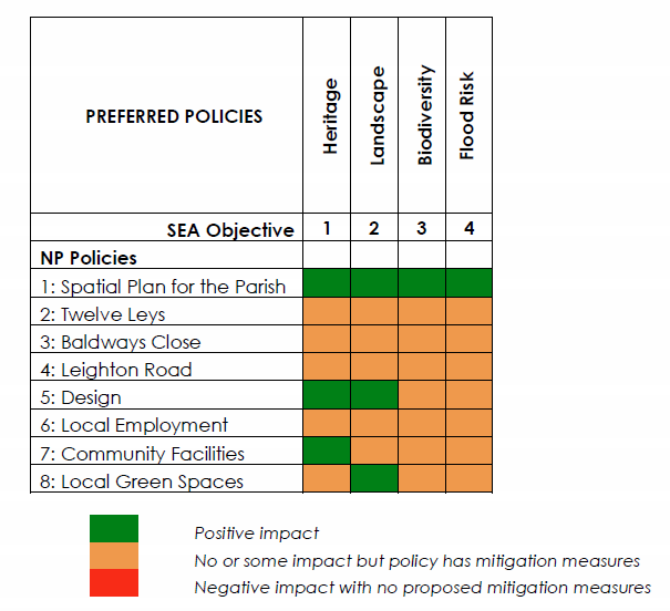 Table B: Assessment of Plan Preferred Policies
8.2 In general terms, the policies have neutral environmental impacts with a small number of positive effects and no negative effects. The spatial plan of Policy 1 focuses growth in the parish entirely on the ‘larger village’ of Wingrave to avoid impacts on the countryside, areas of biodiversity value and areas of flood risk.
8.3 It is also designed to contain the growth of Wingrave village by distributing development around its edge to avoid any major development in a single location that will conflict with the Area of Attractive Landscape designation that surrounds the village. Similarly, in defining the Settlement Boundary tight to the existing village edge but allowing for targeted growth away from heritage assets, the policy has avoided undermining the historic character of the village. In overall terms therefore the policy has positive environmental effects.
8.4 The housing allocation policies 2, 3 and 4 accord with the spatial plan of Policy 1. As each site is a green field on the edge of the village, the focus has been on ensuring the policies contained the key development principles to successfully mitigate the possibility of negative impacts.
8.5 The allocation at Twelve Leys of Policy 2 therefore acknowledges the close proximity of a listed building on its boundary with Nup End Lane and requires a scheme that has full regard to the significance of its setting. The policy also requires a layout and landscape scheme that retain and improve existing hedgerows (with their biodiversity value) and retain the public right of way through the site. Although these could be regarded as positive impacts, or negative impacts without mitigation, the overall assessment is that the policy has been worded to result in neutral impacts.
8.6 Similarly, the allocation off Baldways Close in Policy 3 has to overcome the greenfield, edge of village location of the site. Again, the policy is worded to include key development principles, including the retention of the public right of way as part of an open space through the site and the provision of a strong landscape scheme to define the new village edge to the countryside. This policy too therefore as an overall neutral impact.
8.7 Policy 4 allocates land at Leighton Road, which aside from also being on the edge of the village, presents a greater challenge in the site extending beyond the drawn boundary into the countryside to the east and south. The policy deliberately confines the scheme to a small site on the road frontage, behind the existing belt of protected trees. Its development principles require a strong landscape edge to define the new defensible boundary to the east and south and the minimal loss of protected trees to achieve a satisfactory site access. Although some distance from heritage assets and the Conservation Area, the policy wording acknowledges that there may be impacts on the setting of those assets and requires proposals to have full regard to this matter. In providing for a new off-street car park within the site for the benefit of existing houses on Leighton Road, the policy will improve the appearance of the road as a vista into the village from the east. In overall terms, the policy has a neutral environmental impact
8.8 Policy 5 is intended to complement existing development plan design policy by drawing special attention to the characteristics of the villages when proposals are being made. It will therefore have positive impacts on protecting local heritage assets and landscape character within Wingrave village.
8.9 The promotion of local employment in Policy 6 extends to protecting existing employment uses in the parish and allows for additional employment development at four existing locations in the parish. The policy aims to strike a balance between allowing for the continuing success of those sites in providing local employment opportunities and in protecting the landscape character of their environs. The policy achieves a neutral impact by ensuring the proposals have full regard to their impacts on the landscape in the design of new buildings.
8.10 The community facilities listed in Policy 7 for protection and improvement are valuable community assets that play a key part in defining the character of Wingrave village. In protecting them from unnecessary loss and in allowing for improvements to ensure they remain viable, the policy requires proposals to be appropriate in design terms and, if the facility is a heritage asset, they must have full regard to the special significance of the asset. In doing so, the policy will mitigate any negative impacts to result in a neutral impact.
8.11 Policy 8 identifies a number of Local Green Spaces that meet the criteria of the NPPF to be designated for that purpose. The spaces play an important role in defining the character of the village and will therefore have positive and neutral impacts.
8.12 The assessment is obliged to identify and assess any reasonable alternatives to the proposed policies. These are set out below.
8.13 There were three alternative options for defining the spatial plan in Policy 1. The first (Option A) was to provide for very small, incremental changes to the village edge using saved Policy RA13 of the AVLP and not defining a settlement boundary. The second (Option B) was to plan for a similar scale of growth as that proposed but to allocate it all on one large site at Bell Corner (as defined by the latest SHLAA). The third (Option C) was to provide for the proposed plan and the Bell Corner site. Although an effective case could be made for not defining these options as ‘reasonable’, this report has considered and assessed them anyway.
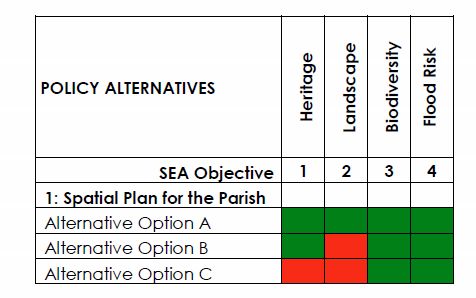 Table C: Assessment of Plan Policy Alternatives (Policy 1)
8.14 The assessment summaries are included in the table above. Option A achieves the same positive assessment as the proposed policy as would be expected given it provides for less overall growth than proposed. However, the option has not been pursued as it would not contribute to achieving sustainable development in the parish by not providing for sufficient housing growth expected of a larger village in the District. This matter will be addressed in the Basic Conditions Statement accompanying the submitted Plan in due course.
8.15 Option B also avoids areas of heritage and biodiversity value and flood risk so has some positive impacts. However, the landscape impact of one larger scheme on the northern edge of the village is assessed as having a negative impact on the Area of Attractive Landscape given its scale and location. Arguably, it is not a reasonable alternative as this scale of proposal would be unlikely to win the majority support of the local community, a factor which must temper the technical assessment of the SEA in relation to a neighbourhood plan.
8.16 Option C is assessed similarly to Option B as it comprises the Bell Corner site. However, it is considered likely that the cumulative traffic impact of the development of more than 200 homes around the village may have a negative impact of the historic character with additional traffic movements around its historic core. However, this should not be overstated and no evidence is presented to validate that concern.
 Table D: Assessment of Plan Policy Alternatives (Policies 2 - 4)
8.17 In respect of the alternatives to the allocation policies, the assessment has considered the impacts of the policies not including the development principles as mitigation measures. In each case, it can be seen above that the loss of those measures risks planning applications that will not properly address the acknowledged environmental issues. That said, there are other development policies that may be used to achieve the same objective, so this assessment should not be over-stated. But in any event, the local community will expect to see such principles included in the policies if they are to be assured that the Plan will be effective.
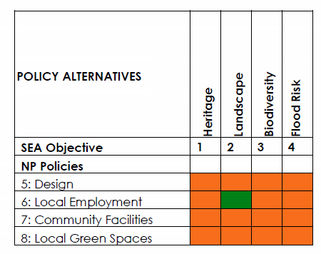 Table E: Assessment of Plan Policy Alternatives (Policies 5 to 8)
8.18 The only reasonable alternative to the remaining policies would be the choice of having no policy on the matter and relying upon the policies of the development plan. In each case, the ‘no policy’ option has made no material difference, as all the policy areas are covered by the development plan and NPPF. The Plan is merely refining those policy areas to reflect their specific relevance to this Parish.
8.19 However, it could be argued that having no Policy 6 may lead to a positive impact on the landscape as the stricter development plan policies on development in the countryside may not allow for the employment outcomes sought by the Plan. That option has not been chosen as it is considered that the social and economic objectives of the Plan should carry more weight. Again, this will be assessed in the round as part of the Basic Conditions Statement in due course,
8.20 The assessment shows that there are no significant adverse effects resulting from the policies of the Plan. The policies have been specifically chosen and formulated to adhere to the principles of sustainable development as defined by the Aylesbury Vale District Local Plan Strategy and the NPPF.
8.21 The conclusion of the draft assessment of the objectives and policies of the Neighbourhood Plan is very encouraging. There is a close correlation between the plan’s objectives and those of the sustainability appraisal, perhaps as should be expected from a community-driven document. The policies have clearly been selected and drafted to ensure that any potential for negative impacts is avoided through site selection and effective policy wording. In a number of cases, the Neighbourhood Plan should deliver positive benefits. There are some reasonable alternative policy options but in no case does that alternative score as well against the chosen policy and there is therefore no case for policy changes as a result.
9 - A description of measures envisaged concerning monitoring
9.1 The Neighbourhood Plan proposes that the progress in its implementation will be assessed using the measures for each objective as set out in Section 6. The data for some of these measures is collected by the District Council in its planning monitoring reports.
In other cases, the Parish Council will endeavour to collect data on an annual basis to report on the progress of the plan. Should any real or potential negative impacts be identified then the Parish and District Councils will seek to review the relevant policies and their implementation.
APPENDIX A : Wingrave & Rowsham Neighbourhood Plan: Baseline Data
| Title | Source | Data | Trends and consequences |
| Historic Landscape | |||
| Settlement Hierarchy | The reasoning and evidence of AVDC’s withdrawn VAP. | The settlement of Wingrave has been identified as a ‘larger village’ in the VAP and as such has been identified as a village that should provide limited growth, in keeping with its character, take account of community-led –planning and to support the provision of services to the wider area. The settlement of Rowsham has been identified as an unidentified settlement and as such there is no expectations for any new housing to be allocated in the plan period.None of the settlements in AVDC have built-up area boundaries. | Due to the rural character of the parish, it is important to keep the settlements’ character. The WRNP may allocate sites for development within or adjoining the villages of Wingrave and Rowsham but only of a small scale in line with their proposed position in the settlement hierarchy. |
| Listed Buildings & Conservation Areas | Wingrave with Rowsham Fact Pack AVDC | There are 35 listed buildings in the parish (three of these are in the hamlet of Rowsham), of which all are Grade II apart from the Grade II* Church St. Peter and St. Paul. Wingrave village has a Conservations Area, the main part of which includes the recreation area, the church and village hall. The smaller part encompasses Nup End Lane. The design of a number of houses in Wingrave, along with many farm buildings, display a unity of scale and appearance recognisable in other Rothschild villages.There is evidence of some historic land use at the sewage works at the end of Castle Street in Wingrave. Wingrave is surrounded by ridge and furrow fields. These tend to be close to the village to the north and east and at some distance to the south and west. Rowsham is also surrounded by evidence of ridge and furrow. Six sites of Archaeological Notification exist in the village, including the Church, Church Farm House, Nup End Farm, the garage building, and a post-medieval windmill site near Mill Lane. | Wingrave with Rowsham Parish has a number of listed buildings and a Conservation Area and therefore needs to ensure that any new development is sensitive to the character of those heritage assets and their settings.
(See Plan C) |
| Biodiversity & Environment | ||||
| Nature Conservation | Wingrave with Rowsham Fact Pack AVDC | There are several notable species sites in and around the parish, some located within the built-up-area, but there are no designated nature sites within or adjoining the villages.There is a row of trees along the entrance to the village of Wingrave on Leighton Road from the northeast and one small cluster to the west just inside the observed settlement boundary of Rowsham that have Tree Preservation Orders (TPOs).
The area to the south of Wingrave and east of Rowsham (known as Hulcott Fields) is a recognised wetland, serving as a winter migration site for several notable species of birds, and is a Biological Notification Site.
|
The WRNP policies will have to show that there will be no harmful effects on the TPOs, notable species sites or Hulcott Fields.
(See Plans D and E) |
|
| Landscape | Wingrave with Rowsham Fact Pack AVDC (and Landscape Character Assessment 2008 and Areas of Sensitive Landscape Study (2008) | The landscape character type for Wingrave is described as Undulating Clay Plateau (type 04) with Vale landscape towards the south (type 08). Wingrave with Rowsham parish has a landscape sensitivity of 0‐50%, showing that the landscape sensitivity to be relatively low.This landscape type in the parish has been designated an Area of Attractive Landscape in the Local Plan (policy RA8) | The WRNP policies will have to show they have responded to the local landscape character.
(See Plan F) |
|
| Flooding | ||||
| Fluvial Flooding | Wingrave with Rowsham Fact Pack AVDC | There is a floodplain (Flood Zone 3) to the south west of Rowsham which continues south east along the parish boundary. There are no areas of flood risk in close proximity to Wingrave village | The WRNP allocation policies must avoid land in Flood Zone 3.(See Plans D & E)
|
|
| Surface Water Flooding | Wingrave with Rowsham Fact Pack AVDC | Numerous areas spread out across the parish are susceptible to surface water flooding. | New development in areas particularly susceptible to surface water flooding will need to effectively demonstrate they can mitigate the risk of flooding without having adverse effects on surrounding areas.
(See Plans D and E) |
|
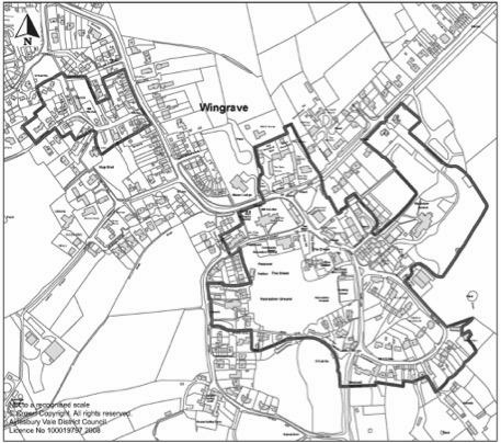
Plan C: Wingrave Conservation Area
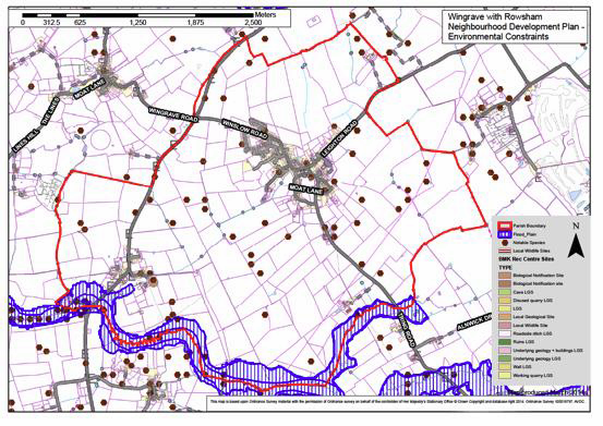 Plan D: Wingrave Environmental Constraints
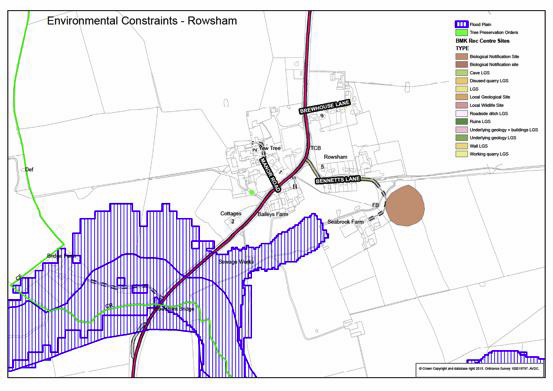 Plan E: Rowsham Environmental Constraints
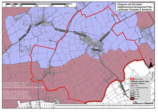 Plan F: Wingrave and Rowsham Landscape Character & Sensitivity
